How to use the Map Compatibility Chart:
The purpose of the Compatibility Chart is to help you figure out which map is suitable for your device and to explain each maps features.
Before you can use the chart, you need to understand a bit about your device first, in particular what NavCore (operating system) is currently installed.
If you don't know what that is, refer to [Please Register or Login to download file] page which will explain how to find out the information for your specific model.
Note: If you neglect this step, you may be wasting a lot of time downloading the wrong map that is inappropriate for your device!
Once you know what NavCore (NC) is installed on your machine, you can refer to the list of NC's on the graduated blue column on the left side of the chart to cross reference. They begin with 7.8xx (or higher) going to 12.xxx (or higher). For example, if you had NC 8.010, you would be referring to the line 8.0xx and reading sideways you'll see there are 7 maps available that you could use which are numbered at the top of the chart. Once you've decided on a particular map, you need to check it already has a Meta code released before you download it otherwise you might find out later it can't be activated and you've wasted your time. You'll find a thread with Meta codes for each map series here. If the one you're interested in is not there, you'll need to look for the next best alternative. Please don't ask for a Meta code, it will be listed if it's available!
Remember that a map with more features is larger than a map with less & will also use more of the available RAM on your device.
If you try and run a fully featured map on a limited RAM model, the device could slow down to such an extent that it may become unstable or even inoperable!Map Features:IQroutes: This uses historical data that has been collected by TomTom to plan a route using real average speeds instead of theoretical maximum speeds on a given route. The device will compare the routes and give the driver the best alternative.
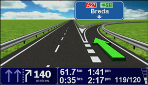
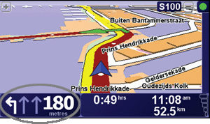
ALG: Advanced Lane Guidance lets you prepare for motorway exits and junctions by showing you which lane you should be in via a visual display on the device.
For some exits and junctions, a still image shows the turning and the lane you should take:

For other exits and junctions, the lane you should take is shown in the Status bar:
 ASR:
ASR: Automatic Speech Recognition allows you to speak the city, street name and house number instead of entering the information via the touch screen. This requires your device to have a built-in microphone and to be using a computer voice.
The devices that can use this feature are:
• GO 950/GO 750/GO 550
• GO 940/GO 740/GO 540
• GO 930/GO 730/GO 630/GO 530
• GO 920/GO 720/GO 520
• GO 910/GO 710
Cspeech: These are the files contained within the map needed for ASR.
TTS: Text to Speech is a function where detailed driving instructions are provided using installed computer voices on the device. The instructions include distances, road names, directions to major cities, distance to next services etc.
HNR: HNR is used in places where one post code is allocated to an entire town or village and not to an area or street in a town EG: Australia. In the UK, a given post code is allocated to say house numbers 1 to 39 and another from 39 to 59 so HNR is not applicable to find an individual house number.


 Forum
Forum


