Afternoon guys
Question on navigating with my 276cx...I am doing an event where I will be provided with a route of waypoints - just point to point, not tied to roads - some of the route will be off road entirely so I was planning on converting to a track then adjusting the track based on topo maps I have on my device. I was told the track should just be permanently overlaid onto the map so when I 'navigate' the route I will also be able to see the tracks in blue (the colour I have set for them)
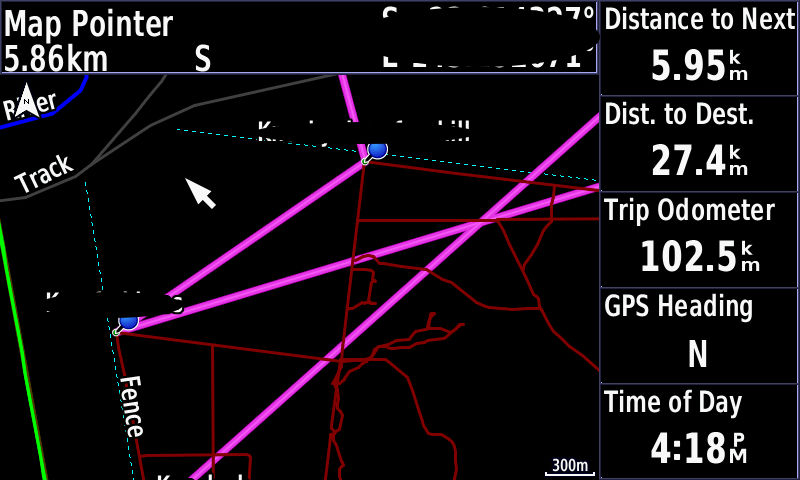
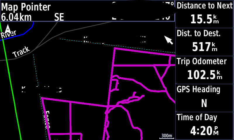
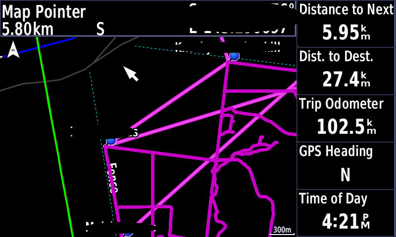
However...when I click navigate on the route on the device the track does not show up, likewise if I navigate the track the route does not show up. If I navigate route then in the tracks section of the main menu I 'view on map' then I can see the route with the track in blue but it isn't navigating so I don't get the datafields on the page.
I basically want to be able to navigate a route whilst seeing the track overlaid onto my devices map, so I can choose to deviate onto the track whilst also being able to see where the route is in relation to any deviation I make.
Hopefully that makes sense!
Any help would be appreciated.
276cx - route vs track
2 posts
• Page 1 of 1
-
TomAn89
offline


- Joined: Thu Jan 05, 2023 12:58 pm
- Posts: 1
- Has thanked: 0 time
- Been thanked: 0 time
Re: 276cx - route vs track
I think navigation can be route only or track only, not both at the same time.
You can navigate a route and perhaps view the track on the map screen at the same time, seeing where it deviates from the route and using the cursor for your location and direction etc..
The way the 276CX handles this seems a bit weird.
If I create a route and navigate it (without roads), any tracks I have set to 'show on map' stay visible at whatever colours I set them to, and the route is shown as the magenta colour used by Garmin.
The nav data fields reflect this as 'Dist to Next', 'Dist to Dest' etc. match for the route.

Then while still navigating the same route, I go into Tracks, go into an individual track and select Navigate, the route disappears and the nav data fields now show the distances etc. in relation to the track.

Next, while navigating the track I selected, I re-activate the route, both the track and route show as magenta, with the route being slightly brighter, and the nav data fields reflect the route stats again, not the tracks.

Deactivate the route, the route is no longer shown and the track returns to it's normal colour
You can navigate a route and perhaps view the track on the map screen at the same time, seeing where it deviates from the route and using the cursor for your location and direction etc..
The way the 276CX handles this seems a bit weird.
If I create a route and navigate it (without roads), any tracks I have set to 'show on map' stay visible at whatever colours I set them to, and the route is shown as the magenta colour used by Garmin.
The nav data fields reflect this as 'Dist to Next', 'Dist to Dest' etc. match for the route.

Then while still navigating the same route, I go into Tracks, go into an individual track and select Navigate, the route disappears and the nav data fields now show the distances etc. in relation to the track.

Next, while navigating the track I selected, I re-activate the route, both the track and route show as magenta, with the route being slightly brighter, and the nav data fields reflect the route stats again, not the tracks.

Deactivate the route, the route is no longer shown and the track returns to it's normal colour

2 posts
• Page 1 of 1
Return to General Discussions about Garmin
-
- Related topics
- Replies
- Views
- Last post
-
- Cannot calculate the route
by jonouk » Tue Sep 30, 2014 6:11 pm - 1 Replies
- 1982 Views
- Last post by jonouk

Tue Sep 30, 2014 10:35 pm
- Cannot calculate the route
-
- New to Garmin: Please help me with route transfer
1, 2by theWolfTamer » Sun Oct 03, 2010 4:40 am - 17 Replies
- 6638 Views
- Last post by Black Wolf

Wed Oct 13, 2010 9:29 pm
- New to Garmin: Please help me with route transfer
-
- Creating a different route than given by Garmin
by Goldberry » Sat Aug 31, 2013 5:15 pm - 2 Replies
- 2040 Views
- Last post by Goldberry

Sun Sep 01, 2013 1:58 pm
- Creating a different route than given by Garmin
-
- Route calculation error
by flo-gps » Thu Dec 23, 2010 7:34 pm - 8 Replies
- 3418 Views
- Last post by flo-gps

Sun Jan 02, 2011 4:02 am
- Route calculation error
-
- Nuvi 250 Route Calculating Problem
by evil1972 » Wed Sep 21, 2011 1:24 am - 0 Replies
- 2171 Views
- Last post by evil1972

Wed Sep 21, 2011 1:24 am
- Nuvi 250 Route Calculating Problem
Who is online
Users browsing this forum: No registered users and 3 guests


 Forum
Forum


