
 Forum
Forum
Sensis version
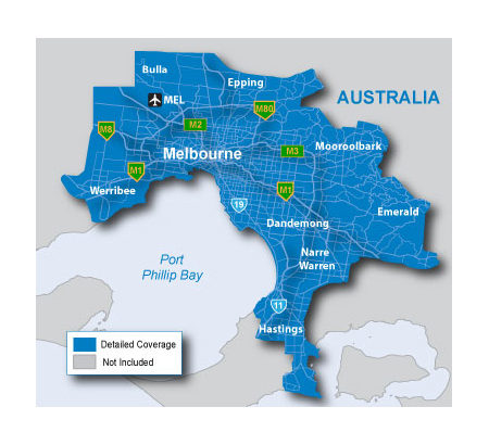
cityXplorer™ Australia - Melbourne - Sensis Public Transportation
- Metro Railway
- Tram
- cityXplorer Features
- Includes the most detailed street data and information available; powered by Sensis.
- Displays the latest points of interest, including hotels, restaurants, parking, entertainment, fuel, shopping and more.
- Provides turn-by-turn directions on your compatible Garmin device.
- Includes detailed route information, including turn restrictions, roundabout guidance, speed limits and lane assist (on compatible devices), and other navigation features.
- Provides enhanced pedestrian mode - street directions that use any available form of public transportation: bus, subway, metrorail, tramway, taxi and more - on compatible devices
Includes detailed coverage for the greater Melbourne area, including Melbourne (MEL) airport, and the cities of:
◦Emerald
◦Dandemong
◦Narre Warren
◦Werribee
◦Bulla
◦Epping
◦Mooroolbark
◦Hastings and more
[Please Register or Login to download file]
Version: 12.10
Released: Mar, 2011
Enhanced pedestrian mode MMR data
2354, 2 1,2
[SIZE="4"][Please Register or Login to download file] [/size]
Melbourne - Navteq version
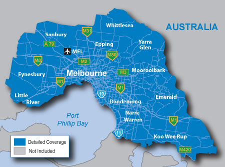
About Coverage
Includes detailed coverage for the greater Melbourne area. Coverage is provided for Melbourne Airport (MEL) and the surrounding cities of Dandenong, Emerald, Epping, Koo Wee Rup and more
[Please Register or Login to download file]
Version: 2011.20
Released: Aug, 2010
locked maps
includes 3D map
Enhanced pedestrian mode MMR data
2273,2 1,2
[SIZE="4"][Please Register or Login to download file] [/size]


