ne n arrive pas a voir le lien de telechargement .quelqu un pourrait-il le publier
merci
Garmin Topo France V5
-
FIXJJ
offline


- Joined: Fri Apr 03, 2015 4:58 am
- Posts: 1
- Has thanked: 0 time
- Been thanked: 0 time
Re: Garmin Topo France V5
FIXJJ wrote:ne n arrive pas a voir le lien de telechargement .quelqu un pourrait-il le publier
Essayer les torrents ygg.
merci
Re: Garmin Topo France V5
ne n arrive pas a voir le lien de telechargement .quelqu un pourrait-il le publier
merci
Les liens sont corrects par contre il y a un problème avec navitotal
Voici une méthode simple pour télécharger
1 Tapez dans google mega.nz ===> une page s'affiche.
2. Choisir Mega.nz ===> la page MEGA ([Please Register or Login to download file] ) s'affiche.
3. Dans le navigateur, complétez la ligne avec les liens ci-dessous. (du / inclus...jusqu'à la fin )
3. Taper sur entrée ==> Le fichier à télécharger s'affiche.
Nord:
/#!LuZGyAaA!bUZbyjmy6edzdH6GqJ1hwMBYEqBbp1kYw2sSxE3Kp_A
Sud:
/#!XjAigACB!ynw6yAjsvQQdXszSSbG7zwUj3tP15vGvAzKaVPW9ivs
Re: Garmin Topo France V5
Small issue: like I always do, I use GMaptool to show up the maps in Mapsource on a PC.
GMaptool splits the img and after installing the batchfile, in Mapsource, the NORD maps displays Topo France 5.
But also the SUD map shows in Mapsource Topo France 5 and overwrites the NORD map.
What I tried is first to join NORD and SUD in Gmaptool in one img, next to split it.
Is this a correct way or is there another way to show both regions in Mapsource/Basecamp?
When I looked to the text dump during the split process, there was a message something like "the difference > 10° "
Re: Garmin Topo France V5
Gunnartom wrote:Small issue: like I always do, I use GMaptool to show up the maps in Mapsource on a PC.
GMaptool splits the img and after installing the batchfile, in Mapsource, the NORD maps displays Topo France 5.
But also the SUD map shows in Mapsource Topo France 5 and overwrites the NORD map.
What I tried is first to join NORD and SUD in Gmaptool in one img, next to split it.
Is this a correct way or is there another way to show both regions in Mapsource/Basecamp?
When I looked to the text dump during the split process, there was a message something like "the difference > 10° "
Both have the same ID number, so you have to give it another ID number, for example I put:
V5Sud: 7455
V5 North: 7452
Re: Garmin Topo France V5
I do not understand why to persist in using MapSource when it is so simple to use BaseCamp.
Put the Maps, as they are in a folder Garmin on a removable device and open the software.
Moreover, the Reverse Engeneering process causes the loss of search by address

Put the Maps, as they are in a folder Garmin on a removable device and open the software.
Moreover, the Reverse Engeneering process causes the loss of search by address

Re: Garmin Topo France V5
Uh, Thanks for sharing my links............
bestiole2 wrote:ne n arrive pas a voir le lien de telechargement .quelqu un pourrait-il le publier
merci
Les liens sont corrects par contre il y a un problème avec navitotal
Voici une méthode simple pour télécharger
1 Tapez dans google mega.nz ===> une page s'affiche.
2. Choisir Mega.nz ===> la page MEGA ([Please Register or Login to download file] ) s'affiche.
3. Dans le navigateur, complétez la ligne avec les liens ci-dessous. (du / inclus...jusqu'à la fin )
3. Taper sur entrée ==> Le fichier à télécharger s'affiche.
Nord:
/#!LuZGyAaA!bUZbyjmy6edzdH6GqJ1hwMBYEqBbp1kYw2sSxE3Kp_A
Sud:
/#!XjAigACB!ynw6yAjsvQQdXszSSbG7zwUj3tP15vGvAzKaVPW9ivs
Last edited by akyta on Tue Aug 07, 2018 11:54 am, edited 1 time in total.
Re: Garmin Topo France V5
hello
le lien ne donne rien pas accès au fichier
le lien ne donne rien pas accès au fichier
-
freeman07
offline


- Joined: Tue May 01, 2018 5:55 am
- Posts: 1
- Has thanked: 0 time
- Been thanked: 0 time
Re: Garmin Topo France V5
Working 

Re: Garmin Topo France V5
Good evening
I think that is the card of france north west and not whole france
I think that is the card of france north west and not whole france
-
perou4
offline


- Joined: Tue Jan 29, 2019 8:14 am
- Posts: 1
- Has thanked: 0 time
- Been thanked: 0 time
Re: Garmin Topo France V5
Good evening
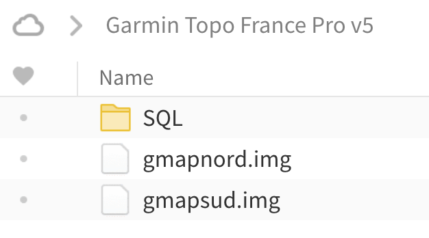
It is the whole FRANCE (two maps Nord and Sud .img)
And If you want TOPO IGN France Raster format .img
Clic here TOPO FRANCE Raster format .img
I think that is the card of france north west and not whole france
It is the whole FRANCE (two maps Nord and Sud .img)
And If you want TOPO IGN France Raster format .img
Clic here TOPO FRANCE Raster format .img
Re: Garmin Topo France V5
It says password needed.
-
larry0200
offline


- Joined: Tue Jun 25, 2013 2:40 pm
- Posts: 1
- Has thanked: 0 time
- Been thanked: 0 time
Re: Garmin Topo France V5
You can create a free account on MEGA of 50GB free 

-
- Related topics
- Replies
- Views
- Last post
-
- Garmin Topo France v2 (Mapsource)
by huntsman » Tue May 25, 2010 4:03 pm - 1 Replies
- 7486 Views
- Last post by jenas

Sun Jul 22, 2012 4:06 pm
- Garmin Topo France v2 (Mapsource)
-
- Garmin Topo France v6 Pro Entire Country + Territories
1 ... 8, 9, 10by GarminNuvi » Wed Jun 30, 2021 4:50 am - 144 Replies
- 48801 Views
- Last post by GarminNuvi

Tue Apr 01, 2025 6:23 pm
- Garmin Topo France v6 Pro Entire Country + Territories
-
- Garmin France topo map ( maps merged & unlocked IMGs North&S
by huntsman » Sat May 22, 2010 2:57 pm - 0 Replies
- 6588 Views
- Last post by huntsman

Sat May 22, 2010 2:57 pm
- Garmin France topo map ( maps merged & unlocked IMGs North&S
-
- TOPO France v4.01 PRO
1, 2by huntsman » Wed Jun 24, 2015 5:34 am - 28 Replies
- 39487 Views
- Last post by plouflechien

Fri Aug 04, 2017 2:11 pm
- TOPO France v4.01 PRO
Who is online
Users browsing this forum: GarminNuvi and 8 guests


 Forum
Forum


