 Forum
ForumHi,
I downloaded sevral files from navitotal to use with primo 2.0 (feb 2012 version); but I get "inactive content" for several file types. All files are 2012 Q2 version but have different numbers:
fda: OK
Buildings: inactive content
maps: OK
hsp: inactive content
ftr: inactive content - but I do not use truck vehicle which may explain
3d landscape: inactive content
fpa: inactive content
speedcam: OK
dem: OK
hnr: inactive content
nng: OK
Any ...

- Contact •
- FAQ •
- Register •
- Login
- View unanswered posts • View active topics
-
 Board index ‹ Site map ‹ News of NaviTotal.com
It is currently Wed Apr 30, 2025 3:29 am
 News of NaviTotal.com
Site map of NaviTotal.com » Forum : NaviTotal.com
NaviTotal.com is a community where you can find all needed for your GPSInactive content
Read more : Inactive content | Views : 6777 | Replies : 3 | Forum : General Discussions about iGO core
895 Map Collections ONLY!!!
895 Map Collections Only. All other posts will be deleted.
1 collection post per member!!
Collections containing ads and/or banners will be deleted.
1 collection post per member!!
Collections containing ads and/or banners will be deleted.
Read more : 895 Map Collections ONLY!!! | Views : 122390 | Replies : 42 | Forum : > Maps v8XX
BlueChart g2: HAF002R - South Africa v2011.5 (v13.00)
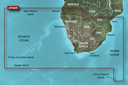
Coverage Details
Detailed coverage of the coast of southern Africa from Namibe, Ang. to Angoche, Moz., including the South African cities of Cape Town and Port Elizabeth. Includes detailed coverage of Durban S. Af. and Maputo, Moz. Also includes detailed coverage of the Tristan da Cunha Group, the island of St. Helena, and the Prince Edward Islands.
Version: 2011.5 (v13.00)
Released: Aug, 2011
lock img
info
- Code: Select all
https://buy.garmin.com/shop/shop.do?pID=33839
- Code: Select all
[url]http://www25.zippyshare.com/v/75989245/file.html[/url]
thanks to ballebar
Read more : BlueChart g2: HAF002R - South Africa v2011.5 (v13.00) | Views : 2658 | Replies : 1 | Forum : New Maps
Papago! X8.5 - Thailand Maps TH120801
Read more : Papago! X8.5 - Thailand Maps TH120801 | Views : 5481 | Replies : 7 | Forum : PaPaGO! Maps
Map of Morocco for Tom Tom GPS with activator map
Morocco_and_Western_Sahara_840_2573
this is the link
http://www.mediafire.com/?vgig7bj62chp8bs
good luck
this is the link
http://www.mediafire.com/?vgig7bj62chp8bs
good luck
Read more : Map of Morocco for Tom Tom GPS with activator map | Views : 5850 | Replies : 1 | Forum : > Maps v8XX
how to change connection mode?
I need to change connection mode from activesync to mass storage! Is there any app to do that on GPS device?
Read more : how to change connection mode? | Views : 3070 | Replies : 1 | Forum : General Discussion
iGo Primo 2 (R3) on an Erisin ES1058V (WinCE.NET v6) system
I have the above mentioned chinese after-market DVD/SatNav System. I've installed iGo Primo2 (version 9.6.5.211211) on an 8Gb micro-SD card. It was working fine, until I tapped on the 'Switch GPS Off' button at the end of a trip. After doing that I now just get a black screen with the words 'No Signal' showing when I try to start the GPS system again. :wallbash:
This happened ...
This happened ...
Read more : iGo Primo 2 (R3) on an Erisin ES1058V (WinCE.NET v6) system | Views : 5434 | Replies : 6 | Forum : General Discussions about iGO core
New Versions of TT Home
TT Home Version 2.9.1.XXXX is now available.
2.9.1.2780 for Windows
2.9.1.1634 for Mac
2.9.1.2780 for Windows
2.9.1.1634 for Mac
Read more : New Versions of TT Home | Views : 2054 | Replies : 0 | Forum : General Discussions about TomTom
NaviTotal Server Downtime
Dear friends and users,
As you noticed the NaviTotal's server was down since last Saturday.
Because, for the second time in about 1 year, the hard drive failed.
As we are using a RAID system it was easier for us to come back with all data, and I can confirm, nothing has been lost!
Also we used the downtime to update the server IPs...
We apologize for the last 5 days and wish you a ...
Read more : NaviTotal Server Downtime | Views : 9104 | Replies : 0 | Forum : Important Forum Announcements
BlueChart g2 - HAE009R - Sin/Mal/Indonesia
BlueChart g2 - HAE009R - Sin/Mal/Indonesia
Version: 2012.51 (v14.01)
Released: Sept, 2012
Part Number: 010-C0884-20 (microSD/SD), 010-C0884-10 (GarminCard), 010-D0563-00 (Download)
Version: 2012.51 (v14.01)
Released: Sept, 2012
Part Number: 010-C0884-20 (microSD/SD), 010-C0884-10 (GarminCard), 010-D0563-00 (Download)
- Includes realistic navigation features showing everything from shaded depth contours and coastlines to spot soundings, navaids, port plans, wrecks, obstructions, intertidal zones, restricted areas, IALA symbols and more.
- Features smooth displays, including seamless transitions between zoom levels and more continuity across chart boundaries.
- Allows users to choose between standard 2-D direct overhead ...
Read more : BlueChart g2 - HAE009R - Sin/Mal/Indonesia | Views : 3797 | Replies : 9 | Forum : New Maps
Last 10 active topics
Statistics
Total posts 164535 • Total topics 17396 • Total members 677512


