It is currently Tue Feb 18, 2025 11:09 pm

News News of New Maps

Site map of New Maps » Forum : New Maps

Finland - TOPO Suomi Pro v2 - Regions

Finland - TOPO Suomi Pro v2 - Regions

Image

  • Displays in 3 languages: Finnish, English and Swedish.
  • Includes routable roads of the entire street and trail network.
  • Features National Land Survey of Finland Topographic database scale 1:5 000-1:10 000.
  • Features inland lake charts (Finland’s Environment Administration), hiking destinations (Finnish Forestry Administration) and nautical base maps (Finnish Maritime Administration).
  • Shows cadastral boundaries and contours.
  • Includes easy plug-n-play microSD™/SD™ cards for compatible devices; also available as a ...
Read more : Finland - TOPO Suomi Pro v2 - Regions | Views : 5540 | Replies : 7


Garmin - TrakMaps Quad Quebec 7.0.1

Garmin - TrakMaps Quad Quebec 7.0.1
Requirements: Compatible with Garmin GPS, PC
Overview: Official trails of the Quebec Federation of Quad Clubs (FQCQ): Summer & Winter
Completely reviewed and improved, serious quad enthusiasts use TrakMaps Quad Quebec to ensure they can always find their way safely.
24,700 km of trails
Power lines, railroad tracks; etc.
16,000+ POIs all along your way
Routable mode to create itineraries, with new integrated map background at 1:50,000
Transparent mode ...
Read more : Garmin - TrakMaps Quad Quebec 7.0.1 | Views : 2815 | Replies : 0


Garmin Topo Suisse V3

Do you have informations about the new map Garmin Topo Swiss V3 ?
Read more : Garmin Topo Suisse V3 | Views : 4010 | Replies : 7


Garmin Navcity Turkey 2011.10-MapSource

Garmin Navcity Turkey 2011.10-MapSource
Requirements: Any PC / PPC / Symbian Garmin Mobile XT installed, Garmin Nuvi, ando other garmin devices
Overview: Map of Turkey
Image


More Info:
Code:
http://www.garmin.com.tr/

Download Instructions:
Garmin Navcity Turkey 2011.10-MapSourceImage or Download netload Garmin Navcity Turkey 2011.10-MapSource Image

MapID: 848
password: ozboss18

inside:
original mapsource with msi installer
unlocked mapsource folder

run reg file on 32BIT System
if you used 64 BIT changeg open reg file with editor and ...
Read more : Garmin Navcity Turkey 2011.10-MapSource | Views : 2740 | Replies : 1


City Navigator Russia NT 2012.40

Image


Includes more than 2,100,000 mi (3,375,000 km) of road coverage, including motorways, national and regional thoroughfares, and local and rural roads.
Contains nearly 6 million updated points of interest, including petrol stations, restaurants, hotels and shopping.
Provides navigational features, such as turn restrictions and speed categories.
Gives turn-by-turn directions on compatible devices.
Version: 2012.40
Released: Dec., 2011
Part Number: 010-D0660-02
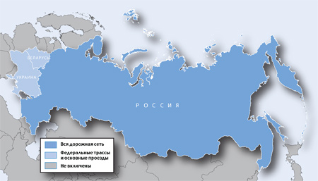

About Coverage

Detailed coverage:

St. Petersburg
Moscow
Republic of Abkhazia
Metropolitan area coverage:

Belarus ...
Read more : City Navigator Russia NT 2012.40 | Views : 3803 | Replies : 8


Roads of Belarus 23.12.2011

info
Code:
http://www.kartaby.org/news/v_novyj_god_s_novoj_kartoj/2011-12-22-74


Free maps
Cyrillic language

For devices (other than 13hh and 14hh series, with the ability to display 3d buildings in devices series 3xhh, 7x5)

Mapsource version 26 bit
20111222_FAM_4857.7z (41,3 MB)
http://www.multiupload.com/6H8GD7MG2K

IMG 26 bit
Belarus gmapsupp .rar (41,1 MB)
http://www.multiupload.com/R3TXTODZUQ


For Mobile XT 24 bit
Mapsource
20111223_FAM_4857_XT.7z (39.9 MB)
http://www.multiupload.com/IAUYLJJNH1

IMG 24 bit

gmapsupp_xt.7z (38.92 MB)
http://www.multiupload.com/R4MFUF689Y

Mapsource 26 bit

FAM_4857.rar (41.97 MB)
http://www.multiupload.com/70S4JKCG39

EDIT By PiEtU: ALL Credits to catymag
Read more : Roads of Belarus 23.12.2011 | Views : 2129 | Replies : 0


UAE & OMAN Masarat Off-Road 2010.20 v.1.0 English for Garmin

Map’s Details:

* 3D Terrain view with high resolution.
* Contours with 100 meters interval 7 meters vertical accuracy.
* Roads Network.
* Desert Tracks.
* Mountain Tracks.
* Unpaved Roads.
* Cities, Villages and Small Settlements.
* Famous Valleys and Mountains.
* Natural Springs, Streams and watercourses.
* Natural Islands.
* Public parks and natural reservations.
* Natural wonders like Caves and blowholes.
* Emergency services like Police stations, hospitals and fuel stations.
* ...
Read more : UAE & OMAN Masarat Off-Road 2010.20 v.1.0 English for Garmin | Views : 5616 | Replies : 5


Garmin AutoDrive Hellas 2.20T-Anavasis 5.32

Here AutoDrive Hellas 2.20T-Anavasis 5.32 set 2in1
https://rapidshare.com/files/3578550...vasis_5.32.rar
Read more : Garmin AutoDrive Hellas 2.20T-Anavasis 5.32 | Views : 2979 | Replies : 6


Brazil Autoguiagps v3.03 2011

Autoguiagps v3.03 2011
Credits to marcio_freitas

MapID 4944

Download:
Locked Image - Autoguiagps v3.03

UnLocked Image - Autoguiagps v3.03
Read more : Brazil Autoguiagps v3.03 2011 | Views : 2360 | Replies : 1


BlueChart g2: HAW005R - The Gulf & Red Sea v2011.5

BlueChart g2: HAW005R - The Gulf & Red Sea v2011.5 (v13.00)
Credits to Ballebar

Features
  • Includes realistic navigation features showing everything from shaded depth contours and coastlines to spot soundings, navaids, port plans, wrecks, obstructions, intertidal zones, restricted areas, IALA symbols and more.
  • Features smooth displays, including seamless transitions between zoom levels and more continuity across chart boundaries.
  • Allows users to choose between standard 2-D direct overhead or 3-D "over the bow" map perspective to ...
Read more : BlueChart g2: HAW005R - The Gulf & Red Sea v2011.5 | Views : 3722 | Replies : 9


Login  •  Register


Statistics

Total posts 163857 • Total topics 17331 • Total members 672345