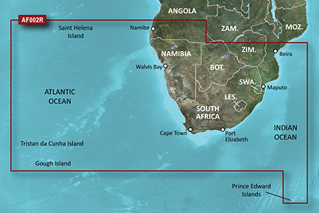
It is currently Tue Feb 18, 2025 10:30 pm

News News of New Maps

Site map of New Maps » Forum : New Maps

BlueChart g2: HAF002R - South Africa v2011.5 (v13.00)

Image


Coverage Details


Detailed coverage of the coast of southern Africa from Namibe, Ang. to Angoche, Moz., including the South African cities of Cape Town and Port Elizabeth. Includes detailed coverage of Durban S. Af. and Maputo, Moz. Also includes detailed coverage of the Tristan da Cunha Group, the island of St. Helena, and the Prince Edward Islands.


Version: 2011.5 (v13.00)
Released: Aug, 2011
lock img


info
Code:
https://buy.garmin.com/shop/shop.do?pID=33839


Code:
[url]http://www25.zippyshare.com/v/75989245/file.html[/url]


thanks to ballebar
Read more : BlueChart g2: HAF002R - South Africa v2011.5 (v13.00) | Views : 2611 | Replies : 1


BlueChart g2 - HAE009R - Sin/Mal/Indonesia

BlueChart g2 - HAE009R - Sin/Mal/Indonesia
Version: 2012.51 (v14.01)
Released: Sept, 2012
Part Number: 010-C0884-20 (microSD/SD), 010-C0884-10 (GarminCard), 010-D0563-00 (Download)

  • Includes realistic navigation features showing everything from shaded depth contours and coastlines to spot soundings, navaids, port plans, wrecks, obstructions, intertidal zones, restricted areas, IALA symbols and more.
  • Features smooth displays, including seamless transitions between zoom levels and more continuity across chart boundaries.
  • Allows users to choose between standard 2-D direct overhead ...
Read more : BlueChart g2 - HAE009R - Sin/Mal/Indonesia | Views : 3727 | Replies : 9


Garmin Malsing Maps NT v5.63

info

Code:
http://www.malsingmaps.com/portal/downloads.php


File: MSM 2012 NT v5.63/gmapsupp.img, length 52580352
Header: 05.08.2012 12:00:46, DSKIMG, XOR 00, V 0.00, Ms 1, 000-00000-00
Mapset: Singapore National Day Special Edition
fat: 1000h - 1200h - 9000h, block 4096
maps: 12, sub-files 13

Sub-file fat length
00004596 MD2 1200h 294994
date 05.08.2012 20:00:41
000-00000-00
00004596 MDR 1400h 7870738
00004596 SRT 2600h 968
I00011F4 TYP 2800h 57133
date 05.08.2012 16:31:42, CP 1252, PID 1, FID 4596
I0F00000 GMP 2A00h 1490058
GMP: ...
Read more : Garmin Malsing Maps NT v5.63 | Views : 2779 | Replies : 1


Pamacol Colombia routable map v.14.4 3D

Pamacol Colombia routable map v.14.4 3D

info
Code:
http://www.pamacol.com/more_maps.php


File: UnLocked_gmapsupp144.img, length 88948736
Header: 31.07.2012 20:58:33, DSKIMG, XOR 00, V 0.00, Ms 1, 000-00000-00
Mapset: COLOMBIA 14.40
fat: 1000h - 1200h - E000h, block 4096
maps: 14, sub-files 15


Sub-file fat length
00001453 MD2 1200h 2417672
date 31.07.2012 15:58:14
000-00000-00
00001453 MDR 1800h 21690974
00001453 SRT 4600h 968
I00005AD TYP 4800h 301
date 30.07.2012 12:45:03, CP 1252, PID 1, FID 1453
I08DC800 GMP 4A00h 2252786 ...
Read more : Pamacol Colombia routable map v.14.4 3D | Views : 2266 | Replies : 0


Topo Pirineos up to v6.1

Image


info
Code:
http://www.topopirineos.blogspot.com/2012/01/topo-pirineos-50.html


unlock image v5

Code:
[url]https://anonfiles.com/file/ae218d92097d40577b54f4093596de1c[/url]


original mapsource v6

Code:
[url]http://www.topopirineos.blogspot.com/2012/01/descargas.html[/url]
Read more : Topo Pirineos up to v6.1 | Views : 5788 | Replies : 3


Garmin GB Discoverer Snowdonia National Park 1:25k v.2.0

Image

Image


Explore Great Britain's national parks and trails with detailed topographic data, including terrain contours, topo elevations, summits, paths, routable roads and geographical points. This product has routable roads and points of interest from NAVTEQ and digital topographic OS Explorer Map as detailed as 1:25,000 scale Landranger maps for Snowdonia National Park from Ordnance Survey of Great Britain.

About Coverage
Features topographic coverage of loops from Conwy to Bala, to Tywyn, to Porthmadog, to ...
Read more : Garmin GB Discoverer Snowdonia National Park 1:25k v.2.0 | Views : 3149 | Replies : 4


Garmin - Topo Adria XL

Garmin - Topo Adria XL
Requirements: PC, Garmin Devices, Garmin XT and Mobile
Overview: Offers digital topographic map detail comparable to 1:25,000 scale
Contains updated map data, including the complete road network, detailed cities, contour lines, summits with names and elevations, mountain trails, urban areas, forests, lakes, rivers, channels, coast lines, islands and more
Provides searchable points of interest, including caves, springs, hotels, museums, restaurants, petrol stations and more

Image


More Info:
Code:
http://www.garmin.si

Download Instructions: ...
Read more : Garmin - Topo Adria XL | Views : 8376 | Replies : 3


City Navigator Southern Africa NT 2013.20

Image

info
Code:
https://buy.garmin.com/shop/shop.do?pID=15535&pvID=30146


Includes more than 750,000 km (465,000 mi) of roads, including motorways, national and regional thoroughfares and local roads, in South Africa.
Displays more than 300,000 points of interest throughout the country, including restaurants, petrol/gasoline stations, lodging, attractions, railways and more.
Gives turn-by-turn directions on your compatible device.
Speaks street names (example: "Turn right on Main Street")
Includes navigational features, such as turn restrictions, roundabout guidance, speed categories and more.
Contains traffic data ...
Read more : City Navigator Southern Africa NT 2013.20 | Views : 3074 | Replies : 4


BlueChart g2 Vision: VUS512L - Mid-Atlantic v2011.5 (v13.00)

VUS512L - Mid-Atlantic v2011.5 (v13.00)


info:
Code:
https://buy.garmin.com/shop/shop.do?pID=8807


Version: 2011.5
Released: Aug, 2011
Part Number: 010-C0741-00 (microSD/SD), 010-D0500-00 (Download)

See your vessel’s precise, on-chart position in relation to navaids, coastal features, restricted areas and more with premium features found in this detailed marine mapping data. Includes all of the BlueChart® g2 features, plus 3-D perspective above and below the waterline, Auto Guidance, high-resolution imagery, and aerial photos of ports, harbors, marinas, landmarks and other points of ...
Read more : BlueChart g2 Vision: VUS512L - Mid-Atlantic v2011.5 (v13.00) | Views : 2503 | Replies : 2


Login  •  Register


Statistics

Total posts 163857 • Total topics 17331 • Total members 672345