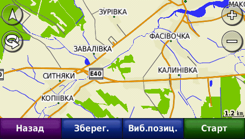
It is currently Tue Feb 18, 2025 10:06 pm

News News of New Maps

Site map of New Maps » Forum : New Maps

Carte Blanche Ukraine 2012.03 (2012.04)

ImageImage


2012.03 (2012.04)

Changes relative to 2011.12
•The total length of road network increased by 6,100 miles and now it is 446,600 miles .
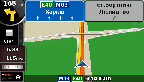
•At stake is added to the road, built and modified to the Football Championship Euro-2012.
•Added detailed coverage for 9 localities, namely: ◦Dnipropetrovsk: Pavlograd, p. Novoivanivka, p. Ternuvatyy corner, with even-Kolomiytseva;
◦Donetsk region: Slavyansk, p. Cheerful, p. Spartacus;
◦Luhansk region: Lisichansk, Severodonetsk.

•Detailed coverage of road network increased by 1.1% and ...
Read more : Carte Blanche Ukraine 2012.03 (2012.04) | Views : 2668 | Replies : 1


Garmin Dakota 10 Base map

Hi,Im new to this great site,I hope I'm posting in the right area.
As the title suggests my brother has a dakota 10 that he uses on his bicycle.He came to me this morning with his Garmin and said he can't get any maps or mapping info at all on it.
He said he had been trying to update the maps,etc,but made a botch of it.He did'nt do a backup of it either.
I'm aTomTom ...
Read more : Garmin Dakota 10 Base map | Views : 2048 | Replies : 2


Garmin VEU709L South Norway (v11.50)

Garmin VEU709L - South Norway v2011.5 (v13.00)
Version: 2011.5
Released: Aug, 2011
Part Number: 010-C0856-00 (microSD/SD), 010-D0504-00 (Download)

Zippyshare.com - gmapsupp.part01.rar
Zippyshare.com - gmapsupp.part02.rar
Zippyshare.com - gmapsupp.part03.rar
Zippyshare.com - gmapsupp.part04.rar
Zippyshare.com - gmapsupp.part05.rar
Zippyshare.com - gmapsupp.part06.rar
Zippyshare.com - gmapsupp.part07.rar
Zippyshare.com - gmapsupp.part08.rar

Image
thanks Ballebar

Code:
https://buy.garmin.com/shop/shop.do?pID=8827
Read more : Garmin VEU709L South Norway (v11.50) | Views : 14702 | Replies : 13


Cyprus3D_Q11.1 Geomatic MapsTM_T.C.Geomatic Ltd© 06_2012

Cyprus3D_Q11.1 Geomatic MapsTM_T.C.Geomatic Ltd© 06_2012
NEW MAP UPDATE just released 06/2012

Image

Download: Locked & UnLocked Images
Cyprus3D_Q11.1_Geomatic_Maps_06_2012.rar


MapID: 1217
File: G:/Garmin/gmapsupp.img, length 12167168
Header: 28.05.2012 15:33:34, DSKIMG, XOR 00, V 0.00, Ms 1, 000-00000-00
Mapset: Cyprus3D_11.1.GeomaticMaps™_Geomatic Ltd© CTDK5_20

Map length s-f CP prio PID FID name
00001217 IDX 4696290 2
I00004C1 TYP 25397 1 1253 1 1217
I0866800 NT 7418073 1 1253 24 L 1 1217 Cyprus3D_11.1.GeomaticMaps™_Geomatic Ltd© CTDK5_2012
MAPSOURC MPS 364 1

Data ...
Read more : Cyprus3D_Q11.1 Geomatic MapsTM_T.C.Geomatic Ltd© 06_2012 | Views : 3945 | Replies : 8


Topo Germany 2012 Pro - DVD/gmap

Topo Deutschland 2012 Pro (v5.0) - DVD/gmap-Version - unlocked
(...formerly known as "MapSource version")

Image

Product Info:
Code:
http://www.garmin.com/de/topo/topodeutschland2012/

  • Original DVD content with
    • unlocked gmap folder
    • Multilang. Setup for Map, BaseCamp, MapInstall & WebUpdater
  • MapID 2388
  • extracted size 2.52GB
  • with new TYP file that shows streetnames (can be replaced by attached old TYP file I0000954_alt.TYP if needed)
Download:
  • Hoster: uploaded.to & NETuploaded.com
  • Crypter: relink.us & linksave.in
  • Link format: single links, click'n'load and dl container
  • Download ...
Read more : Topo Germany 2012 Pro - DVD/gmap | Views : 8233 | Replies : 10


City Navigator Philippines NT 2012.20

Code:
File:      gmapprom.img, length 36208640
Header:      29.05.2012 08:45:38, DSKIMG, XOR 00, V 12.20, Ms 0, D349502AG045
Mapset:      CN Philippines NT 2012.20 ALL

Data MPS
 V: template (1)
 U: SXWYH-NFTSP-7H7Y9-Y93PG-55EXE
 F: PID 1, FID 2687, CN Philippines NT 2012.20


Code:
http://download.garmin.com/ph/download/MapUpgrade/201220/201220_typeA.exe


Thanks to Airion
Read more : City Navigator Philippines NT 2012.20 | Views : 3265 | Replies : 6


City Navigator Indonesia NT 2012.20

City Navigator Indonesia NT 2012.20

Code:
File:      gmapprom.img, length 106496000
Header:      24.05.2012 09:58:56, DSKIMG, XOR 00, V 12.20, Ms 0, D278738AG035
Mapset:      CN Indonesia NT 2012.20 ALL

Data MPS
 V: Indonesia 1, Indonesia 2, Indonesia 4, Indonesia 3 (1)
 U: VUVJ2-T8KLZ-9Q48R-JGVSL-66QUJ
 U: ZC3SD-Y2QKJ-HR5EY-4RRUC-3SYFQ
 F: PID 1, [B]FID 2686[/B], CN Indonesia NT 2012.2


Type A - locked Image + JCV

Code:
http://download.garmin.com/id/download/MapUpgrade/201220/201220_typeA.exe


Type B - locked Image + JCV

Code:
http://download.garmin.com/id/download/MapUpgrade/201220/201220_typeB.exe


Type C - locked Image

http://download.garmin.com/id/download/MapUpgrade/201220/201220_typeC.exe ...
Read more : City Navigator Indonesia NT 2012.20 | Views : 5580 | Replies : 9


City Navigator Middle East & Northern Africa NT 2013.20

City Navigator Middle East & Northern Africa NT 2013.20
Version: 2013.20
Released: July, 2012
Part Number: 010-D0748-00

Navigate streets in the Middle East & Northern Africa with confidence. City Navigator Middle East & Northern Africa NT provides detailed road maps for your device and boasts thousands of points of interest throughout the region, so you can navigate with exact, turn-by-turn directions to any address or intersection. Route to restaurants, gas stations, lodging, attractions and more. ...
Read more : City Navigator Middle East & Northern Africa NT 2013.20 | Views : 7779 | Replies : 12


BlueChart g2 - HEU713L - Finland v2012.2 (13.52)

BlueChart g2 - HEU713L - Finland v2012.5 (14.00)
Versio: 2012.5
Released: Aug, 2012
Osanumero: 010-D0591-00 (Download) 010-C0860-20 (microSD/SD) 010-C0860-10 (GarminCard)

See your vessel’s precise, on-chart position in relation to navaids, coastal features, anchorages, obstructions, waterways, restricted areas and more with this detailed marine mapping data. Also includes Safety Shading and Fishing Charts (in compatible units), smooth data transition between zoom levels, harmonious transition across chart borders and reduction of chart discontinuities in coverage areas.
  • ...
Read more : BlueChart g2 - HEU713L - Finland v2012.2 (13.52) | Views : 3033 | Replies : 2


HRU001R - Russian Inland Waterways v2012 (v13.50)

HRU001R - Russian Inland Waterways v2012 (v13.50)
Version: 2012
Released: Feb, 2012
Part Number: 010-D0820-00

See your vessel’s precise, on-chart position in relation to navaids, coastal features, anchorages, obstructions, waterways, restricted areas and more with this detailed marine mapping data. Also includes Safety Shading and Fishing Charts (in compatible units), smooth data transition between zoom levels, harmonious transition across chart borders and reduction of chart discontinuities in coverage areas.

  • Includes realistic navigation features showing ...
Read more : HRU001R - Russian Inland Waterways v2012 (v13.50) | Views : 2605 | Replies : 0


Login  •  Register


Statistics

Total posts 163857 • Total topics 17331 • Total members 672345