I have problems with ManageMapsource and win7 64bit
The card is not installed.
Some who know this
It works on WinXP and Win7 32bit
Hoping for some help :-)
It is currently Tue Feb 18, 2025 10:12 pm
 News of New Maps
Site map of New Maps » Forum : New Maps
Brazil Autoguia v2.39
Brazil Autoguia v2.39
Credits to marcio_freitas
MapID: 1641
Autoguia 2.39 Unlocked & Locked Image - FileServe
or
Autoguia 2.39 Unlocked & Locked Image - FileFactory
File: G:/Garmin/gmapsupp.img, length 186662912
Header: 02.09.2011 13:49:25, DSKIMG, XOR 00, V 0.00, Ms 1
Mapset: 1, 2, 3, 4, 5, 6, 7, 8, 9, 10, 11, 12, 13, 14, 15,
Data MPS
V: 1, 2, 3, 4, 5, 6, 7, 8, 9, 10, 11, 12, 13, 14, 15, (1)
F: ...
Read more : Brazil Autoguia v2.39 | Views : 2147 | Replies : 0
BulMaps Balkans v.3.2
Navigation routing map of the Balkan Peninsula.
3154
Contains maps of Bulgaria, Romania, Serbia, Macedonia, Greece, Albania, Croatia, Montenegro, Bosnia and Herzegovina and the European part of Turkey.
Bulgaria: Includes maps of 300 cities and resorts, as well as a detailed road network.
Romania: the country's road network, Bucharest, Timisoara, Arad, Ploiesti, Constanta, Galati, Braila, Satu Mare, Baia Mare.
Serbia: Includes maps of 30 cities, the country's road network.
Macedonia: the country's road network, Skopje, ...
Read more : BulMaps Balkans v.3.2 | Views : 3098 | Replies : 7
Projeto Tracksource Brasil 11.08
Brazilian Tracksource Project, roads and urban areas map, version 11.08 (August 28, 2011), all unlocked.
gmapsupp.img file to copy directly to Garmin memory card, 210.91 MB
http://rapidshare.com/files/860142578/gmapsupp_v1108.zip
PC installation file for MapSource, 189.77 MB
http://rapidshare.com/files/4203376873/TRC-Brasil_v1108.exe
Mac installation file for MapSource, 230.07 MB
http://rapidshare.com/files/3816752819/TRC-Brasil.gmapi_v1108.zip
Read more : Projeto Tracksource Brasil 11.08 | Views : 2318 | Replies : 0
Bluechart G2 VEU469S Stockholm and Mälaren v2010.2 (v11.50)
Bluechart G2 VEU469S Stockholm and Mälaren v2010.2 (v11.50)
Credits to condmaster
PID 1, FID 2025, region 5,35
Bluechart G2 VEU469S Stockholm and Mälaren v2010.2 Locked (511.13 MB)
Bluechart G2 VEU469S Stockholm and Mälaren v2010.2 UnLocked (511.13 MB)
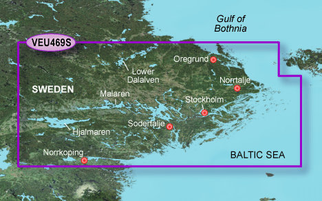
Credits to condmaster
PID 1, FID 2025, region 5,35
Bluechart G2 VEU469S Stockholm and Mälaren v2010.2 Locked (511.13 MB)
Bluechart G2 VEU469S Stockholm and Mälaren v2010.2 UnLocked (511.13 MB)
- Code:
File:      G:/gmapsupp.img, length 535961600
Header:      27.02.2010 11:30:42, DSKIMG, XOR 00, V 11.50, Ms 0
Mapset:      VEU469S-Stockholm and Malaren
Read more : Bluechart G2 VEU469S Stockholm and Mälaren v2010.2 (v11.50) | Views : 2892 | Replies : 0
Malsingmaps Malaysia/Singapore/Brunei NT 2011.30
Malsingmaps Malaysia/Singapore/Brunei NT 2011.30
Credits to tom1807
MapID: 451
nuvi 2575R/ 2565/ 2465/ 1460/ 1350 Series/ 765/ 255W
Download: Here or Here
nuvi 3790V/ 3790
Download: Here or Here
nuvi 1250
Download: Here or Here
nuvi 205/ 205W
Download: Here or Here
Only Images Locked & Unlocked:
Download: Here
File: G:/gmapprom.img, length 45551616
Header: 28.07.2011 09:30:52, DSKIMG, XOR 00, V 11.30, Ms 0
Mapset: Malsingmaps NT 2011.30 ALL
Map length s-f CP prio PID FID ...
Read more : Malsingmaps Malaysia/Singapore/Brunei NT 2011.30 | Views : 2374 | Replies : 0
City Navigator Southeast Asia NT v7.0
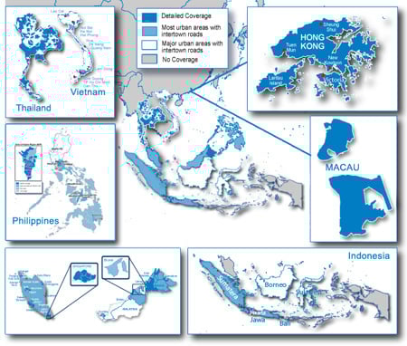
About Coverage
Features detailed maps of major metropolitan areas in Singapore, Malaysia, Thailand, Indonesia, Hong Kong, Macau, Philippines, and Bali.
Includes motorways, national and regional thoroughfares and local roads throughout the country.
Displays points of interest throughout the country, including restaurants, lodging, attractions, shopping and more.
Gives turn-by-turn directions on your compatible device.
Speaks street names (example: "Turn right on Main Street")
Includes navigational features, such as turn restrictions, roundabout guidance, speed categories and ...
Read more : City Navigator Southeast Asia NT v7.0 | Views : 3518 | Replies : 1
BlueChart g2 - HSA009R - Amazon River 2015.5 (17.00)
BlueChart g2 - HSA009R - Amazon River 2015.5 (17.00)
See your vessel’s precise, on-chart position in relation to navaids, coastal features, anchorages, obstructions, waterways, restricted areas and more with this detailed marine mapping data.
See your vessel’s precise, on-chart position in relation to navaids, coastal features, anchorages, obstructions, waterways, restricted areas and more with this detailed marine mapping data.
- Shaded depth contours, coastlines, spot soundings, navaids, port plans, wrecks, obstructions, intertidal zones, restricted areas and IALA symbols.
- Seamless transitions between zoom levels and more continuity across chart boundaries.
- Standard 2-D direct overhead or 3-D “over the bow” ...
Read more : BlueChart g2 - HSA009R - Amazon River 2015.5 (17.00) | Views : 2790 | Replies : 0
Ukraine Luxena Navlux 2011 Q4

Release Date : 08/17/2011 Version : 2011 Q4
Detailed coverage of 509 settlements of Ukraine (274 large and 235 small)
311,000 km of roads covering 000 km and 219 dirt roads. The total length of road network - 530 000 km. United all 30 108 settlements of Ukraine. Number of points of interest (POI) increased to 130,500 . see. description of the release .
UPDATED! Odessa
Added to fully function: movement of strips [Lane ...
Read more : Ukraine Luxena Navlux 2011 Q4 | Views : 2445 | Replies : 2
cityXplorer Africa - Johannesburg, South Africa
cityXplorer Africa - Johannesburg, South Africa
About Coverage
Includes detailed road maps and points of interest for the city of Johannesburg, South Africa, with the ability to navigate using buses, tramway, metro and suburban rail systems (where available. Not all cities include all public transit types).
Features detailed coverage for the greater Johannesburg area, including OR Tambo International (JNB) airport, and the cities of:
- Sandton
- Randburg
- Midrand
- Germinston
- Roodepoort
- Kempton Park
- Boksbur
- Benoni
- Springs
Read more : cityXplorer Africa - Johannesburg, South Africa | Views : 2170 | Replies : 0
Last 10 active topics
Statistics
Total posts 163857 • Total topics 17331 • Total members 672345