 Forum
ForumFriluftskartan TOPO Sweden Pro v2 - Mellersta and Södra Norrland
Venture On
Preparing for a great outdoor adventure? TOPO Sweden - Mellersta and Södra Norrland provides detailed topographic coverage in the Mellersta and Södra Norrland region of Sweden, with searchable points of interest and 3-D elevation data for compatible Garmin devices. This highly detailed topographic product is generated from a resolution of 1:50,000, and 1:100,000 over the Swedish part of the Scandinavian mountains. The included ...

- Contact •
- FAQ •
- Register •
- Login
- View unanswered posts • View active topics
-
 Board index ‹ Site map ‹ News of NaviTotal.com ‹ News of New Maps
It is currently Tue Dec 16, 2025 5:51 pm
 News of New Maps
Site map of New Maps » Forum : New Maps
Friluftskartan TOPO Sweden Pro v2 - Mellersta and Södra Norr
Read more : Friluftskartan TOPO Sweden Pro v2 - Mellersta and Södra Norr | Views : 3740 | Replies : 1
Friluftskartan TOPO Sweden Pro v2 - Norra Norrland
Friluftskartan TOPO Sweden Pro v2 - Norra Norrland
Venture On
Preparing for a great outdoor adventure? TOPO Sweden - Norra Norrland provides detailed topographic coverage in the Norra Norrland region of Sweden with searchable points of interest and 3-D elevation data for compatible Garmin devices. This highly detailed topographic product is generated from a resolution of 1:50,000, and 1:100,000 over the Swedish part of the Scandinavian mountains. The included preloaded microSD™/SD™ card offers plug-and-play functionality ...
Read more : Friluftskartan TOPO Sweden Pro v2 - Norra Norrland | Views : 4032 | Replies : 0
Malsingmaps - MSM NT v5.13
Malsingmaps - MSM NT v5.13 (Brunei / Malaysia / Singapore Maps)
Released 09 Apr 2011
Free map
Download from one the following links:
Download Image & JCV - Megaupload
OR
Download Image & JCV - Mediafire
Quick Installation Note:
Released 09 Apr 2011
Free map
Download from one the following links:
Download Image & JCV - Megaupload
OR
Download Image & JCV - Mediafire
Quick Installation Note:
- Extract & Copy gmapsupp.img to \Garmin\
- Extract & Copy Product.JCV to \Garmin\JCV\
Read more : Malsingmaps - MSM NT v5.13 | Views : 2679 | Replies : 0
Friluftskartan TOPO Sweden Pro v2 - Götaland
Friluftskartan TOPO Sweden Pro v2 - Götaland
Credits to catymag friend who provided it
Preparing for a great outdoor adventure? TOPO Sweden - Götaland provides detailed topographic coverage in the Götaland region of Sweden with searchable points of interest and 3-D elevation data for compatible Garmin devices. This highly detailed topographic product is generated from a resolution of 1:50,000, and 1:100,000 over the Swedish part of the Scandinavian mountains.
Friluftskartan Pro is intended for use ...
Read more : Friluftskartan TOPO Sweden Pro v2 - Götaland | Views : 4594 | Replies : 1
Bluechart G2 - HSA001R - South America East Coast v12.50
Bluechart G2 - HSA001R - South America East Coast v12.50
Released: Feb, 2011
MAP ID:2289
Features
Released: Feb, 2011
MAP ID:2289
Features
- Includes realistic navigation features showing everything from shaded depth contours and coastlines to spot soundings, navaids, port plans, wrecks, obstructions, intertidal zones, restricted areas, IALA symbols and more.
- Features smooth displays, including seamless transitions between zoom levels and more continuity across chart boundaries.
- Allows users to choose between standard 2-D direct overhead or 3-D "over the bow" map perspective ...
Read more : Bluechart G2 - HSA001R - South America East Coast v12.50 | Views : 5419 | Replies : 2
Garmin cityXplorer Sydney - Sensis & Navteq
Garmin cityXplorer Sydney - Sensis & Navteq
Sensis version
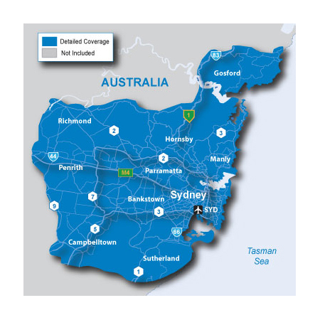
cityXplorer™ Australia - Sydney - Sensis Public Transportation
Sensis version
cityXplorer™ Australia - Sydney - Sensis Public Transportation
- Metro Railway
- Tram
- Ferry
- cityXplorer Features
- Includes the most detailed street data and information available; powered by Sensis.
- Displays the latest points of interest, including hotels, restaurants, parking, entertainment, fuel, shopping and more.
- Gives turn-by-turn directions on your compatible Garmin device.
- Includes detailed information, such as turn restrictions, roundabout guidance, speed limits (compatible devices ...
Read more : Garmin cityXplorer Sydney - Sensis & Navteq | Views : 2550 | Replies : 1
Garmin cityXplorer Melbourne - Sensis & Navteq
Garmin cityXplorer Melbourne - Sensis & Navteq
Sensis version
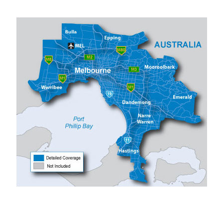
cityXplorer™ Australia - Melbourne - Sensis Public Transportation
Sensis version
cityXplorer™ Australia - Melbourne - Sensis Public Transportation
- Metro Railway
- Tram
- cityXplorer Features
- Includes the most detailed street data and information available; powered by Sensis.
- Displays the latest points of interest, including hotels, restaurants, parking, entertainment, fuel, shopping and more.
- Provides turn-by-turn directions on your compatible Garmin device.
- Includes detailed route information, including turn restrictions, roundabout guidance, speed limits and lane assist (on compatible devices), ...
Read more : Garmin cityXplorer Melbourne - Sensis & Navteq | Views : 3232 | Replies : 6
Garmin CityXplorer - Adelaide - Sensis
Garmin CityXplorer - Adelaide - Sensis
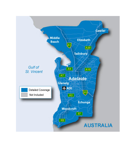
cityXplorer™ Australia - Adelaide - Sensis Public Transportation
cityXplorer™ Australia - Adelaide - Sensis Public Transportation
- Metro Railway
- Tram
- cityXplorer Features
- Includes the most detailed street data and information available; powered by Sensis.
- Displays the latest points of interest, including hotels, restaurants, parking, entertainment, fuel, shopping and more.
- Gives turn-by-turn directions on your compatible Garmin device.
- Includes detailed information, such as turn restrictions, roundabout guidance, speed limits (compatible devices only) and other navigation features. ...
Read more : Garmin CityXplorer - Adelaide - Sensis | Views : 1878 | Replies : 1
Garmin cityXplorer Brisbane - Sensis & Navteq
Garmin cityXplorer Brisbane - Sensis & Navteq
SENSIS version: Released: Mar, 2011

Navigate the big city like your hometown with cityXplorer for your street navigator. This convenient download puts the latest street maps and most up-to-date points of interest on your device, so you'll have updated local information for shopping, restaurants, hotels, entertainment, parking and so much more.
About Coverage
Includes detailed coverage for the greater Brisbane area, including Brisbane International Airport (BNE) and ...
SENSIS version: Released: Mar, 2011
Navigate the big city like your hometown with cityXplorer for your street navigator. This convenient download puts the latest street maps and most up-to-date points of interest on your device, so you'll have updated local information for shopping, restaurants, hotels, entertainment, parking and so much more.
About Coverage
Includes detailed coverage for the greater Brisbane area, including Brisbane International Airport (BNE) and ...
Read more : Garmin cityXplorer Brisbane - Sensis & Navteq | Views : 2189 | Replies : 1
Topo Hispania v 2.00
Topo Hispania v 2.00
Credits to catymag
SinRenKor today launched the Topo Hispania v 2:00
As you will read during the installation, the map is based on spanish official data which are currently free and from non-commercial projects.
In a brief analysis we can confirm that in some areas it's better than the Garmin Spain Topo V4, that now is more complete just because has DEM files
The map is free, not locked, opaque and ...
Read more : Topo Hispania v 2.00 | Views : 3361 | Replies : 3
Last 10 active topics
Statistics
Total posts 166475 • Total topics 17592 • Total members 691597


