It is currently Tue Feb 18, 2025 10:39 pm

News News of New Maps

Site map of New Maps » Forum : New Maps

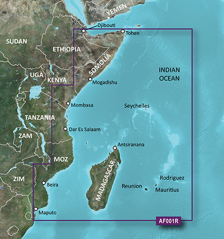
BlueChart g2 HAF001R - Eastern Africa v2015.5 (17.00)

BlueChart g2 HAF001R - Eastern Africa v2015.5 (17.00)

PID 1, FID 3840, region 2,1

Image:
Locked: Download

UnLocked: Download


Image
Read more : BlueChart g2 HAF001R - Eastern Africa v2015.5 (17.00) | Views : 2676 | Replies : 2


HEU062R - Russian Inland Waterways v17.50 (2016)

HEU062R - Russian Inland Waterways v17.50 (2016)

See your vessel’s precise, on-chart position in relation to navaids, coastal features, anchorages, obstructions, waterways, restricted areas and more with this detailed marine mapping data.

  • Shaded depth contours, coastlines, spot soundings, navaids, port plans, wrecks, obstructions, intertidal zones, restricted areas and IALA symbols.
  • Seamless transitions between zoom levels and more continuity across chart boundaries.
  • Standard 2-D direct overhead or 3-D “over the bow” map perspective ...
Read more : HEU062R - Russian Inland Waterways v17.50 (2016) | Views : 16255 | Replies : 3


TOPO maps locked, unlocked and SQL

Hello,
I shall like having some precision concerning TOPO maps :

1-What are the differences between the locked maps and the unlocked maps ?
What are the use of locked maps if it is necessary to unlock to use them ?
What the locked maps provide more ?

2-What is the use of the SQL ?

Thank you for your answers

Kind regards.
Read more : TOPO maps locked, unlocked and SQL | Views : 1782 | Replies : 0


GARMIN MAPS FOR TRUCK HELP !!!!

Hy i need please Europe maps for truck for Garmin


THANKS
Read more : GARMIN MAPS FOR TRUCK HELP !!!! | Views : 3396 | Replies : 24


Garmin - Tracks4Africa Maps Traveller’s 2015.10

Garmin - Tracks4Africa Maps Traveller’s 2015.10
Requirements: for all Garmin Devices
Overview:T4A GPS Maps are a set of 16 regional GPS maps covering most parts of the African continent. If you are a tourist or business traveller and looking for a GPS map to guide you through Africa then you would appreciate the accuracy and detail of T4A GPS Maps.
Map Coverage
•843 883km of roads, detailed tourist coverage and fully navigable (4%increase from 14.05) ...
Read more : Garmin - Tracks4Africa Maps Traveller’s 2015.10 | Views : 2064 | Replies : 1


Garmin - Tracks4Africa Maps Traveller’s 2015.05

Garmin - Tracks4Africa Maps Traveller’s 2015.05
Requirements: for all Garmin Devices
Overview:T4A GPS Maps are a set of 16 regional GPS maps covering most parts of the African continent. If you are a tourist or business traveller and looking for a GPS map to guide you through Africa then you would appreciate the accuracy and detail of T4A GPS Maps.
Map Coverage
•843 883km of roads, detailed tourist coverage and fully navigable (4%increase from 14.05) ...
Read more : Garmin - Tracks4Africa Maps Traveller’s 2015.05 | Views : 2111 | Replies : 1


Can & How to load Europe to nuvi 2599LMT with USA.

I have nuvi 2599LMT with USA map.
I want add e.g. whole Europe to it - can I and how.
I assume it will be loaded onto SD card.
Read more : Can & How to load Europe to nuvi 2599LMT with USA. | Views : 1725 | Replies : 1


City Navigator Turkey NTU 2016.30

City Navigator Turkey NTU 2016.30

FID: 4078

Turkey Image: (+ADDS) Coverage
SID: Fast Routing, Insta Search, Traffic Trends v3
JCV: JCV_LaneAssistPortraitFull , JCV_Nuvi-40,50-Android
3D:
Locked Image: (+ADDS): Download
Image

UnLocked Image: (+ADDS): Download

Image
Code: Select all
File:      G:\Garmin\gmapprom.img, length 234168320
Header:      05.02.2016 18:21:33, DSKIMG, XOR 00, V 20.16, Ms 0, D561503AG040
Mapset:      CN Turkey NTU 2016.30 ALL

Data MPS
 V: CN Turkey NTU 2016.30 ALL (0)
 U: 00000-00000-00000-00000-00000
 F: PID 1, FID 4078, CN Turkey NTU 2016.30

JCV_LaneAssistPortraitFull: ...
Read more : City Navigator Turkey NTU 2016.30 | Views : 1961 | Replies : 0


City Navigator Chile NT 2017.10

City Navigator Chile NT 2017.10

Navigate the streets with confidence. This product provides detailed road maps and points of interest for your device, so you can navigate with exact, turn-by-turn directions to any address or intersection.
  • Shows more than 172,000 km (107,000 mi) of roads, including motorways, national and regional thoroughfares and local roads.
  • Displays more than 40,000 points of interest throughout the country, including restaurants, lodging, attractions and shopping.
  • Gives turn-by-turn ...
Read more : City Navigator Chile NT 2017.10 | Views : 2373 | Replies : 2


BlueChart g2 - HEU802X - Mediterranean Sea and Iberian Peninsula 2015.5 (17.00)

BlueChart g2 - HEU802X - Mediterranean Sea and Iberian Peninsula 2015.5 (17.00)

See your vessel’s precise, on-chart position in relation to navaids, coastal features, anchorages, obstructions, waterways, restricted areas and more with this detailed marine mapping data.
  • Shaded depth contours, coastlines, spot soundings, navaids, port plans, wrecks, obstructions, intertidal zones, restricted areas and IALA symbols.
  • Seamless transitions between zoom levels and more continuity across chart boundaries.
  • Standard 2-D direct overhead or 3-D ...


Login  •  Register


Statistics

Total posts 163857 • Total topics 17331 • Total members 672345