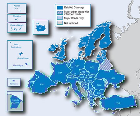
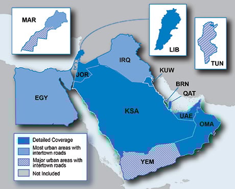
It is currently Tue Feb 18, 2025 10:57 pm

News News of New Maps

Site map of New Maps » Forum : New Maps

BlueChart g2 - HEU704L - France 2015.0 (16.50)

BlueChart g2 - HEU704L - France 2015.0 (16.50)

See your vessel’s precise, on-chart position in relation to navaids, coastal features, anchorages, obstructions, waterways, restricted areas and more with this detailed marine mapping data.
  • Shaded depth contours, coastlines, spot soundings, navaids, port plans, wrecks, obstructions, intertidal zones, restricted areas and IALA symbols.
  • Seamless transitions between zoom levels and more continuity across chart boundaries.
  • Standard 2-D direct overhead or 3-D “over the bow” map ...
Read more : BlueChart g2 - HEU704L - France 2015.0 (16.50) | Views : 3894 | Replies : 6


BlueChart g2 - HCA015R - Canada g2 v2015.0 (16.50)

BlueChart g2 - HCA015R - Canada g2 v2015.0 (16.50)

See your vessel’s precise, on-chart position in relation to navaids, coastal features, anchorages, obstructions, waterways, restricted areas and more with this detailed marine mapping data.
  • Shaded depth contours, coastlines, spot soundings, navaids, port plans, wrecks, obstructions, intertidal zones, restricted areas and IALA symbols.
  • Seamless transitions between zoom levels and more continuity across chart boundaries.
  • Standard 2-D direct overhead or 3-D “over the bow” ...
Read more : BlueChart g2 - HCA015R - Canada g2 v2015.0 (16.50) | Views : 3078 | Replies : 5


Garmin Navcity Turkey 2015.T1

Garmin Navcity Turkey 2015.T1
Requirements: Any PC / PPC / Symbian Garmin Mobile XT installed, Garmin Nuvi, ando other garmin devices
Overview: The most recent and the best map of Turkey. It includes restaurants, hotels, banks and gas stations: the most up to date POIs .

Image


More Info:
Code: Select all
http://www.baytekin.com.tr/harita_guncelle.aspx

Download Instructions:
This board requires you to be registered and logged-in to view hidden content.


inside:
unlocked image


Hoster
filefactory.com
share-online.biz
Read more : Garmin Navcity Turkey 2015.T1 | Views : 2279 | Replies : 1


City Navigator Europe NT 2016.10

Image

FID: 3886


MS LOCK
This board requires you to be registered and logged-in to view hidden content.


This board requires you to be registered and logged-in to view hidden content.


IMG.UNL
This board requires you to be registered and logged-in to view hidden content.


This board requires you to be registered and logged-in to view hidden content.


3D UNL
This board requires you to be registered and logged-in to view hidden content.


This board requires you to be registered and logged-in to view hidden content.


D2504190A_JCV for 7X5/ZUMO/1XXX
This board requires you to be registered and logged-in to view hidden content.


This board requires you to be registered and logged-in to view hidden content.


D3084160A_JCV Full-Screen
This board requires you to be registered and logged-in to view hidden content.


This board requires you to be registered and logged-in to view hidden content.


D2331200A_G2S
This board requires you to be registered and logged-in to view hidden content.


This board requires you to be registered and logged-in to view hidden content.


Image

This board requires you to be registered and logged-in to view hidden content.


Image

This board requires you to be registered and logged-in to view hidden content.
Read more : City Navigator Europe NT 2016.10 | Views : 31662 | Replies : 18


TOPO Norway Experience PRO v3

TOPO Norway Experience PRO v3

Image
Prepare for your next great outdoor adventure in Norway with this highly detailed topographic mapping product. With fully routable maps and Garmin ActiveRouting¹, it contains versatile route planning for walking and cycling.

  • Integrates topographic vector map data from Statens Kartverk at a scale of 1:50,000 on compatible devices
  • Displays content from the Norwegian Trekking Association like huts and trails
  • Shows customized activity routes using ActiveRouting, showing ...
Read more : TOPO Norway Experience PRO v3 | Views : 6507 | Replies : 6


NA 2016.10 Need JCV split screen file for NUVI 40/50

On the City Navigator North America NT 2016.10 maps previously posted , can someone please add/post the .JCV split screen file for the Garmin Nuvi 40/50 GPS. I have tried the ones posted and they don't seem to work on my unit.

Thank you.
Read more : NA 2016.10 Need JCV split screen file for NUVI 40/50 | Views : 1802 | Replies : 0


For Sell: Garmin Alpha 100 GPS Training & Tracking Collar

NO SPAMMING!!!!

tendriver
Super Mod
Read more : For Sell: Garmin Alpha 100 GPS Training & Tracking Collar | Views : 1381 | Replies : 0


Garmin - TrekMap Italia v4 Pro

Garmin - TrekMap Italia v4 Pro
Requirements: compatible Garmin Devices
Overview:Prepare for your next great adventure anywhere in Italy with this topographic mapping product — now enhanced with highly detailed maps for 9 Italian regions. With fully routable maps and Garmin ActiveRouting¹, it contains versatile route planning for hiking as well as climbing.

Integrates topographic data from Regional Cartography Offices at a scale of 1:10,000 to provide the latest generation of vectorized maps on compatible ...
Read more : Garmin - TrekMap Italia v4 Pro | Views : 11439 | Replies : 8


Onroute Motorkaart MiddenEuropa 2015

Onroute Motorkaart MiddenEuropa 2015
Requirements: for all Garmin Devices
Overview: As a motorcyclist you want to go as quickly as possible from A to B, but on a nice route.
Midden Europe version includet( Benelux, Germany, Austria , Switzerland , France , Italy , Spain , Portugal, England, Scotland, Wales, Ireland, Denmark, Sweden, Norway, Finland ).

Image

• automatically finds the best motorcycle roads
• both in unit and PC
• Super easy to use ...
Read more : Onroute Motorkaart MiddenEuropa 2015 | Views : 2900 | Replies : 14


City Navigator Middle East & Northern Africa NT 2016.10

Image

FID: 3363

MS LOCK
This board requires you to be registered and logged-in to view hidden content.


FULL IMG.UNL
This board requires you to be registered and logged-in to view hidden content.


JCV_G2S_db_3D_SID
This board requires you to be registered and logged-in to view hidden content.


EAST 3D_JCV
This board requires you to be registered and logged-in to view hidden content.


gmapdem
This board requires you to be registered and logged-in to view hidden content.
Read more : City Navigator Middle East & Northern Africa NT 2016.10 | Views : 11523 | Replies : 7


Login  •  Register


Statistics

Total posts 163857 • Total topics 17331 • Total members 672345