 Forum
ForumFile: gmapsupp.img, length 426737664
Header: 18.03.2013 05:24:40, DSKIMG, XOR 00, V 0.00, Ms 1, 000-00000-00
Mapset: Tracksource - www.tracksource.org.br
fat: 1000h - 1200h - 2A000h, block 8192
maps: 36, sub-files 169
Sub-file fat length
00000339 MD2 1200h 3363268
date 18.03.2013 02:23:13
000-00000-00
00000339 MDR 1600h 63918511
00000339 SRT 5800h 920
90000737 LBL 5A00h 619143
CP 1252, map created with cgpsmapper
90000737 NET 5C00h 1276741
90000737 NOD 5E00h 3897559
90000737 RGN 6200h 2665088
90000737 TRE 6600h ...

- Contact •
- FAQ •
- Register •
- Login
- View unanswered posts • View active topics
-
 Board index ‹ Site map ‹ News of NaviTotal.com ‹ News of New Maps
It is currently Tue Feb 18, 2025 10:06 pm
 News of New Maps
Site map of New Maps » Forum : New Maps
BlueChart g2 Vision - VEU506S - Crete-Cyprus v2012.5 (v14.00
BlueChart g2 Vision - VEU506S - Crete-Cyprus v2012.5 (v14.00)
Version: 2012.5
Released: Aug, 2012
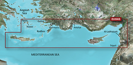
thanks pietu
Version: 2012.5
Released: Aug, 2012
- Code: Select all
VEU506S-UNL.rar
[url]http://www.share-byte.net/Lho4vo[/url]
thanks pietu
Read more : BlueChart g2 Vision - VEU506S - Crete-Cyprus v2012.5 (v14.00 | Views : 2071 | Replies : 1
HRU001R - Russian Inland Waterways v2012 (v13.50)
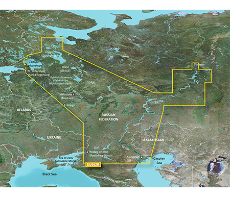
HRU001R - Russian Inland Waterways v2012 (v13.50)
Version: 2012
Released: Feb, 2012
MapID: 2538
- Code: Select all
HRU001R_-_Russian_Inland_Waterways_v2012_(v13.50).rar
[url]http://www.share-byte.net/XPKNTq[/url]
Read more : HRU001R - Russian Inland Waterways v2012 (v13.50) | Views : 2282 | Replies : 0
Tracks4Africa Maps Traveller’s 201210 v02
Tracks4Africa Maps Traveller’s 201210 v02
Requirements: for all Garmin Devices
Overview:T4A GPS Maps are a set of 16 regional GPS maps covering most parts of the African continent. If you are a tourist or business traveller and looking for a GPS map to guide you through Africa then you would appreciate the accuracy and detail of T4A GPS Maps.

More Info:
Download Instructions:
Tracks4Africa 201210 v02 or Download Tracks4Africa 201210 v02
password: ...
Requirements: for all Garmin Devices
Overview:T4A GPS Maps are a set of 16 regional GPS maps covering most parts of the African continent. If you are a tourist or business traveller and looking for a GPS map to guide you through Africa then you would appreciate the accuracy and detail of T4A GPS Maps.
More Info:
- Code: Select all
http://www.t4a.co.za
Download Instructions:
Tracks4Africa 201210 v02
or Download Tracks4Africa 201210 v02 password: ...
Read more : Tracks4Africa Maps Traveller’s 201210 v02 | Views : 1959 | Replies : 1
City Navigator India NT 2013.10

FID 2894
City Navigator India NT 2013.10 with JCV, SID.part1.rar
http://www.share-byte.net/YF5v5j
City Navigator India NT 2013.10 with JCV, SID.part2.rar
http://www.share-byte.net/aFLezr
Read more : City Navigator India NT 2013.10 | Views : 2832 | Replies : 0
Garmin Atlas Czech 2013 NT + 3D
Garmin Atlas Czech 2013 NT + 3D and Adresy CZ v2
Adresy CZ v 2: Map ID: 583
Atlas Czech 2011 NT: Map ID: 1649
https://mega.co.nz/#!65xEiCTR!blSZKzpkFP6_8o0J1wCrEQGVUB0XYAiT_pCVEumlgNI
Adresy CZ v 2: Map ID: 583
Atlas Czech 2011 NT: Map ID: 1649
https://mega.co.nz/#!65xEiCTR!blSZKzpkFP6_8o0J1wCrEQGVUB0XYAiT_pCVEumlgNI
Read more : Garmin Atlas Czech 2013 NT + 3D | Views : 6308 | Replies : 6
BlueChart g2 Vision - VEU479S - Portugal
BlueChart g2 Vision - VEU479S - Portugal
Version: 2012.5
Released: Aug, 2012
Part Number: 010-D0416-00
See your vessel’s precise, on-chart position in relation to navaids, coastal features, restricted areas and more with premium features found in this detailed marine mapping data. Includes all of the BlueChart® g2 features, plus 3-D perspective above and below the waterline, Auto Guidance, high-resolution imagery, and aerial photos of ports, harbors, marinas, landmarks and other points of interest.
- ...
Read more : BlueChart g2 Vision - VEU479S - Portugal | Views : 1834 | Replies : 1
BlueChart g2 Vision - VEU019R - Alborg-Amsterdam
BlueChart g2 Vision - VEU019R - Alborg-Amsterdam
Version: 2012.5
Released: Aug, 2012
Part number: 010-D0447-00
See your vessel’s precise, on-chart position in relation to navaids, coastal features, restricted areas and more with premium features found in this detailed marine mapping data. Includes all of the BlueChart® g2 features, plus 3-D perspective above and below the waterline, Auto Guidance, high-resolution imagery, and aerial photos of ports, harbors, marinas, landmarks and other points of interest.
- ...
Read more : BlueChart g2 Vision - VEU019R - Alborg-Amsterdam | Views : 1617 | Replies : 1
BlueChart g2 Vision - VEU018R - Benelux Offshore & Inland Waters 2015.5 (17.00)
BlueChart g2 Vision - VEU018R - Benelux Offshore & Inland Waters 2015.5 (17.00)
See your vessel’s precise, on-chart position in relation to navaids, coastal features and restricted areas with premium features found in this detailed marine mapping data. Includes all of the features of our BlueChart® g2 product, plus 3-D perspective above and below the waterline, Auto Guidance, high-resolution imagery, and aerial photos of ports, harbors, marinas and landmarks.
See your vessel’s precise, on-chart position in relation to navaids, coastal features and restricted areas with premium features found in this detailed marine mapping data. Includes all of the features of our BlueChart® g2 product, plus 3-D perspective above and below the waterline, Auto Guidance, high-resolution imagery, and aerial photos of ports, harbors, marinas and landmarks.
- Shaded depth contours, coastlines, spot ...
Read more : BlueChart g2 Vision - VEU018R - Benelux Offshore & Inland Waters 2015.5 (17.00) | Views : 2408 | Replies : 1
BlueChart g2 Vision - VEU015R - Aegean Sea & Sea of Marmara
BlueChart g2 Vision - VEU015R - Aegean Sea & Sea of Marmara v2014.0 (v15.50)

See your vessel’s precise, on-chart position in relation to navaids, coastal features, restricted areas and more with premium features found in this detailed marine mapping data. Includes all of the BlueChart® g2 features, plus 3-D perspective above and below the waterline, Auto Guidance, high-resolution imagery, and aerial photos of ports, harbors, marinas, landmarks and other points of interest.
See your vessel’s precise, on-chart position in relation to navaids, coastal features, restricted areas and more with premium features found in this detailed marine mapping data. Includes all of the BlueChart® g2 features, plus 3-D perspective above and below the waterline, Auto Guidance, high-resolution imagery, and aerial photos of ports, harbors, marinas, landmarks and other points of interest.
- Includes ...
Read more : BlueChart g2 Vision - VEU015R - Aegean Sea & Sea of Marmara | Views : 12814 | Replies : 18
Last 10 active topics
Statistics
Total posts 163857 • Total topics 17331 • Total members 672345


